Bruised and Battered- A Tribute to the people of Mousuni


Visiting the island twice (before Bulbul and Amphan) due to photography assignments, the Islanders, have become quite used to me. Seeing my interest in shooting birds and landscape, they insisted me to see the other side of Mousuni, which is much unexplored. Breathtakingly beautiful, the other side of the island is home to various flora and fauna species residing in the mangroves along the Chinai river bank.
With consecutive blow of two cyclones, in a span of 6 months, Bulbul on November 9th, 2019, Amphan on May 20th, 2020, the islanders are now in threat of existence.
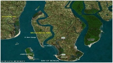 |
| The Mousuni Island |
In
this documentation, I present you a series of a photographic journey through my
lens, on how Mother Nature’s wrath can spell disaster to destroy an abode of
peace and happiness to horror and uncertainty.
October
2019....The Peaceful and Tranquil....Mousuni....
During
my visit on October 2019, to frame the beautiful Sunbirds, Kingfishers
and above all the grand Paradise
Flycatcher, for a Zoology Project, I witnessed some of the lesser explored
part of the island, with the help of the Islanders. Every part was enchanting
and unscathed, unlike the Baliara area, which was full of tourists, with loud
music and dirt strewn all over the beaches. Walking along the flood plains I
witnessed the sun rising from the eastern horizon, amid chirping of Bee-Eaters,
Orioles, Jungle Maynah’s....
 |
Mousuni
2019.
The beautiful sunrise on the Chinai river flood plains

To reach Mousuni, one has to cross the Chinai River. A boat ride along the mangroves to photograph birds rewarded me some breathtaking landscapes along virgin mangroves. The mangroves act as a shield to withstand erosion as well as cyclonic storms.

Mousuni 2019. Sona
Mondal and her family collect the
last batch of fish caught by their men folk...early morning. Fishing is their only source of earning. They
will sell their catch in the market and in the hotels in the beaches. I am
indebted to her as she allowed me to sneak peek into their life and frame it.
[February 2020, post Cyclone Bulbul
When I re-visited in February 2020, for my solo photo project, the pleasant sight of serene beautiful island is nowhere to be seen (leaving the Baliara area, the tourist spot). Instead, I witnessed Mother Nature’s wrath, with uprooted trees, agony of the displaced people, wastelands, and abandoned houses. Cyclone Bulbul, which made landfall on 9/11/2019...at top speed of 120km/hr, spilled the venom.
 |
| Mousuni, February 2020 “Loss of Sand Cover” |
Uprooted trees strewn on the Baliara beach
greeted us. With the washing away of the subsoil layer and gradual loss of sand
cover, the trees which once withstood the storms are uprooted.

Sona Mondal, the
happy homemaker, who posed for me and allowed me to frame their life and
struggle, is now dumb and unstable. While exploring at dawn, as I walked
towards their settlement, I met her, staring at the debris, which was once her
home. Still in a state of shock, she pays a regular visit to rekindle the sweet
memories. Her home is completely devastated as Bulbul made a landfall on that fateful day. Taking shelter in
makeshift camp, she returned the next day only to see the debris. When I returned in 2021, I met her
again post Amphan, roaming around the place all alone...this time her hut
remnants washed away.
 |
| Mousuni, February 2020. “Wastelands” |
The after-effects of Bulbul have claimed
the fertile patch of land and have turned it in a wasteland. The entire green
patch is now filled with sand.
 |
| Mousuni, February 2020 |
With
his boat lost, he is now left to fend with hand held net as high tide approaches. With a family of six
to feed, his wife and mother helps him, after completing the household work.
Fishes are now not easy to find, as water around the mouth has become warm due
to constant pollution due to dumping of leftovers from the tourist camps on the
Baliara Camp sites.


Mousuni, February 2020.
Shocking yet Disturbing
A near barren severely deforested area
along the Muri Ganga river bank was a quite disturbing sight for me. Severe
stream bank erosion is almost a common sight everywhere. The fishermen blamed
the local administration for the damage as they repeatedly pleaded on preserving the mangroves.
[March 2021, post Cyclone Amphan
and Pandemic]
Keeping
contact with the “Islanders”
virtually (during lockdown), with their insistence, I came to know of the
disastrous impact of Amphan. As the lockdown was lifted, I revisited the island
with a group of NGO’s, on March 20. On way, I witnessed the horror. The
beautiful and serene nature was bruised and battered. In every patch, turns
and by lanes destruction greeted us. As I walked through the villages, tales of
loss and agony poured in. To my
surprise many have left their home of generations to mainland, to work in
cities.
 |
| Mousuni March 2021 “The Injured Plains” |
Shot at dawn on the Chinai river bank, a
woman collects dry wood. The tress which once proudly adorned the area lay dead
as saline water lashed out.
 |
| Mousuni March 2021 “The Fragile Mangrove Ecosystem” |
The indiscriminate destruction of the mangroves has
led to severe river bank erosion. To
my shock I saw the entire stretch of the Chinai river flood plain almost
barren, where once the Mangroves proudly stood. This had hastened shore bank
erosion.

 |
| Mousuni, March 2021. ”The Might of Amphan”... |
The severity of Amphan uprooted the tree into a
bundle of entangled trash...
 |
Mousuni,
March 2021. The Remnant of a once happy abode...
 |
| Mousuni March 2021 “The revenge of Mother Nature” |
Pollution and dirt is strewn all over the Baliara
near the estuary, as uprooted trees grace the once beautiful scenario. Over
utilizing the estuarine resources and indiscriminate felling of adjoining
mangroves have taken its toll.
 |
Mousuni
March 2021 “The Ray of Hope”
Amid destruction, fisher-woman rushes to the sea shore to gather her cast net, she laid last night. With Amphan claiming their home, they have moved to a makeshift Govt. shelter home.
With large tracts of land gradually disappearing, invasion of brackish water in the farmlands breaching the embankments, massive shore erosion, and loss of income in the past two years due to the Covid pandemic, which battered the tourism industry in the island, the islanders are now in a brink of existence. Many Islanders are now leaving the sinking Island to other place for, as uncertainty looms over the islands existence. The fishermen communities, they are now opting out to other professions outside the island.


Comments
Post a Comment